
Watershed Ecology
A watershed is the area of land where all of the water that is under it or drains off of it goes into the same place. In other words it is:
“…that area of land, a bounded hydrologic system, within which all living things are inextricably linked by their common water course and where, as humans settled, simple logic demanded that they become part of a community.” (John Wesley Powell)
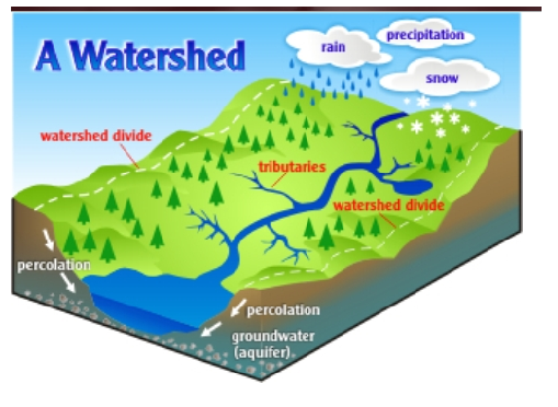
Figure 1. Watershed Diagram. Taken from:http://watersheddiscipleship.org/page/what-watershed
Ecology is the scientific study of interactions of organisms with one another and with the physical and chemical environment. Although it includes the study of environmental problems such as pollution, the science of ecology mainly involves research on the natural world from many viewpoints, using many techniques.

Ecology is a science that contributes considerably to our understanding of evolution, including our own evolution as a species. All evolutionary change takes place in response to ecological interactions that operate on the population, community, ecosystem, biome and biosphere levels. Studies conducted within the scientific discipline of ecology may therefore focus on one or more different levels: on populations of a single species, on an interacting community involving populations of many species, on the movement of matter and energy through a community within and ecosystem, on large scale processes within a biome, or on global patterns within the biosphere.
Watershed Ecology is the study of watersheds as ecosystems, primarily the analysis of interacting biotic and abiotic components within a watershed’s boundaries. Defining an ecosystem as a functioning natural unit with interacting biotic and abiotic components in a system whose boundaries are determined by the cycles and flux of energy, materials and organisms. Then a watershed is just one of many types of ecosystems.
The Physical Template
Within the watershed, various forms of matter, including water, are in constant cyclic flow. Through these processes, an abiotic (non-living) template of air, water, and soil is formed, upon which life can exist. The physical template of watershed structure is ultimately determined by varying combinations of climatic, geomorphic, and hydrologic processes.
- Climatic Factors:

Figure 2. Climatic factors.
Taken from: http://cfpub.epa.gov/watertrain/pdf/modules/WatershedEcology.pdf
Climate refers to an aggregate of both average and extreme conditions of temperature, humidity, and precipitation (including type and amount), winds, and cloud cover, measured over an extended period of time.
Climate heavily influences watershed vegetation communities, streamflow magnitude and timing, water temperature, and many other key watershed characteristics.
- Geomorphological factors:
Geomorphology refers specifically to the study of the landforms on the earth and the processes that change them over time. Fluvial geomorphology, referring to structure and dynamics of stream and river corridors, is especially important to understanding the formation and alteration of the stream or river channel as well as the flood plain and associated upland transitional zone; this is a critical discipline for effective, long-term watershed management.
- Hydrology factors:
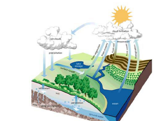
Figure 3. Hydologic cycle. Taken from: http://cfpub.epa.gov/watertrain/pdf/modules/WatershedEcology.pdf
Hydrology is the science of water in all its forms (liquid, gas, and solid) on, in and over the land areas of the earth, including its distribution, circulation and behavior, its chemical and physical properties, together with the reaction of the environment (including all living things) on water itself.
The three elements of the physical template and other factors also interact significantly in determining the structure and composition of a watershed and its biotic communities.
As a result of different combinations of these formative processes, different types of watersheds are created. Here are some examples that show how different from one another watersheds of different origin and physical template conditions can be:

Figure 4. Different valley types in watersheds. In the top left: Valley Type II, moderately steep, gentle sloping side slopes often in colluvial valleys. Top right: Valley Type VI, moderately steep, fault controlled valleys. Bottom:Valley Type VIII, wide, gentle valley slope with well developed floodplain adjacent to river terraces. Taken from: http://cfpub.epa.gov/watertrain/moduleFrame.cfm?parent_object_id=657
Watershed Estructure
This includes structure of flowing waters (mainly rivers and streams with associated riverine wetlands and riparian zones), still waters (lakes and associated basin-type wetlands and shorelands), and upland areas of watersheds.

Figure 5. Watershed estructure. Taken from: http://cfpub.epa.gov/watertrain/pdf/modules/WatershedEcology.pdf
Flowing Systems
- Longitudinal (in an upstream and downstream direction) :
Flowing water systems commonly go through structural changes en route from their source tomouth. Three zones are usually recognized– headwaters, where flow is usually lowest of any where along the system, slope is often steepest, and erosion is greater than sediment deposition; transfer zone, the middle range of the stream where slope usually flattens somewhat, more flow appears, and deposition and erosion are both significant processes; and the downstream end’s depositional zone,where flow is highest but slope is minimal and deposition of sediment significantly exceeds erosion most of the time.
- Lateral (across the channel, floodplains and hillslopes) :
Significant variation occurs among stream types, but a common pattern includes the channel, the deepest part of which is called the thalweg; low floodplains that a re flooded frequently, and higher floodplains that are rarely inundated; terraces, which are former floodplains that a downcutting stream no longer floods; and hillslopes or other upland areas extending up-gradient to the watershed boundary.
- Vertical (surface waters, ground water and their interactions):
It is always important to recognize that water bodies are not purely surface features; rivers and streams constantly interact with groundwater aquifers and exchange water, chemicals, and even organisms. Over its entire length, a stream often varies between influent reaches where surface water leaks downward into the aquifer, and effluent reaches where the stream receives additional water from the aquifer.
- Temporal (through time, from temporary response to evolutionary change):
The dimension of time is important because rivers and streams are perpetually changing. Structure as described in the other three dimensions above should never be considered permanent, and watershed managers should always think of structure not just as what is there now, but in terms of the structural changes in progress and their rates of occurrence.
“Still” Waters
Lentic systems generally include lakes and ponds. A lake’s structure has a significant impact on its biological, chemical, and physical features. Some lentic systems may be fresh water bodies, while others have varying levels of salinity. Most basin-type wetlands are also generally grouped within lentic systems; these are areas of constant soil saturation or inundation with distinct vegetative and faunal communities. Lakes and ponds are almost always connected with streams in the same watershed, but the reverse is not nearly as often true.
The method of lake formation is the basis for classifying different lake types. Natural processes of formation most commonly include glacial, volcanic, and tectonic forces while human constructed lakes are created by dams or excavation of basins. Although on human time scales we may think of lakes as permanent, they are ephemeral features on the landscape. They are found in depressions in the earth’s surface in regions where water is available to fill the basin. Over time, lakes fill with sediments and organic material while outlets tend to erode the lake rim away
Watershed Functions
Transport and storage:
Because a watershed is an area that drains to a common body of water, one of its main functions is to temporarily store and transport water from the land surface to the water body and ultimately (for most watersheds) onward to the ocean. But, in addition to moving the water, watersheds and their water bodies also transport sediment and other materials, energy, and many types of organisms. It is important when recognizing the transport function to also recognize temporary retention or storage at different locations in the watershed.
- Transport and storage of water
One can view a watershed as an enormous precipitation collecting and routing device, but transportation and storage of water actually involves a complicated mix of many smaller processes.
Even before precipitation reaches the ground, it interacts with vegetation. Trees and other vegetation are responsible for interception and detention of some of the rainfall, leading to some evaporation and also slowing the amount reaching the ground via throughfall and giving it time for better infiltration to groundwater (one form of storage).
Saturation of soils, occurring when precipitation exceeds infiltration, leads to overland flow and, over longer time frames, drainage network development. The consistent flow of water in channels affects and shapes channel development and morphology in ways that seek dynamic equilibrium with the job to be done (moving water downstream).
- Transport and storage of sediments
Watersheds also collect and transport sediments as a major function. Sediment transport and storage is a complex network of smaller watershed processes, like the water processes described above, and actually is inseparable from water transport and storage.
Sediment related processes mostly involve erosion and deposition, but sediment transport and storage also play a longer-term role in soil development.
Cycling and transformation:
Various elements and materials (including water) are in constant cycle through watersheds, and their interactions drive countless other watershed functions. Elements like carbon, nitrogen, and phosphorus comprise the watershed’s most important biogeochemical cycles. Cycling involves an element of interest’s transport and storage, change in form, chemical transformation and adsorption.
- Nutrient Spiraling:
The flow of energy and nutrients in ecosystems are cyclic, but open-ended. True systems, in both an environmental and energetic context, are either “open” (meaning that there is some external input and/or output to the cyclic loop) or “closed” (meaning that the system is selfcontained).
In watersheds, streams and rivers represent an open-system situation where energy and matter cycles, but due to the unidirectional flow, the matter does not return to the spot from whence it came. Also, nutrients “spiral” back and forth among the water column, the bodies of terrestrial and aquatic organisms, and the soil in the stream corridor en route downstream. Hence, the concept of nutrient “spiraling” implies both movement downstream and multiple exchanges between terrestrial and aquatic environment, as well as between biotic and abiotic components of the watershed.
- The Cycling of Carbon and Energy:
In food webs, carbon and the subsequent synthesized energy is cycled through trophic (food web) levels. Energy transfer is considered inefficient, with less than 1 percent of the usable solar radiation reaching a green plant being typically synthesized by consumers, and a mere 10 percent of energy being typically converted from trophic level to trophic level by consumers.

Figure 6. Carbon cycle. Taken from:http://www.visionlearning.com/en/library/Earth-Science/6/The-Carbon-Cycle/95
- Nitrogen (N):
N2 (gaseous state) is not usable by plants and most algae. N-fixing bacteria or blue-green algae transform it into nitrite (NO2) or ammonia (NH4). N-fixation, precipitation, surface water runoff, and groundwater are all sources of nitrogen. Under aerobic conditions, NH4+ is oxidized to NO3- (nitrate) in the nitrification process. Losses of N occur with stream outflow, denitrification of nitrate (NO3) to N2 by bacteria, and deposition in sediments. Unlike P, inorganic N ions are highly soluble in water and readily leach out of soils into streams. NH4+ (ammonium) is the primary end-product of decomposition.

Figure 7. Nitrogen cycle. Taken from:http://faculty.www.umb.edu/jennifer.bowen/research.php
- Phosphorus (P):
Phosphorus in unpolluted watersheds is imported through dust in precipitation, or via the weathering of rock. Phosphorus is normally present in watersheds in extremely small amounts; usually existing dissolved as inorganic orthophosphate, suspended as organic colloids, adsorbed onto particulate organic and inorganic sediment, or contained in organic water. Soluble reactive phosphorus (consisting of ionic orthophosphates) is the only significant form available to plants and algae and constitutes less than 5 percent of the total phosphorus in most natural waters.

Figure 8. Phosphorus cycle. Taken from:http://en.wikipedia.org/wiki/Phosphorus_cycle
Ecological succession:
Succession is a process that circulates significant amounts of the watershed’s energy, water and materials from the abiotic environment back into the biotic, and from one set of predominant organisms on to a subsequent set of dominant organisms. Characteristic forms of succession may be typical of specific parts of the watershed. Succession
builds and gradually changes vegetational structure that serves many critical functions such as maintaining varied habitat and reestablishing renewable resources for human use.

Figure 9. Ecological succession in waters. Taken from:http://sciencebitz.com/?page_id=41
Watershed Ecology in Costa Rica
History
The concept of watershed management has evolved in the country with global trends and with the acceptance and use of a watershed as a planning unit in the various programs that the country has carried out.
Watershed management has been talked in Costa Rica since the beginning of 60’s, when institutions responsible for water resources as ICE, SENARA and AyA, studied watershed’s hydrological performance in order to solve specific problems, such as sectoral water demands and the establishment of project with emphasis in energy and irrigation.


Since the 70’s people have been working on the theme of watersheds considering other purposes such as controlling landslides or floods and mitigation of sediment in dams built.
In the following years, in the late 70’s, agencies or entities as MAG incorporated within the scope of water management, emphasizing its work in soil conservation, reforestation of degraded areas and the protection of forested areas. It plays host to the time the next idea:
“The set of techniques used for analysis, protection, rehabilitation, conservation and land use watershed with purposes of control and conserve water resources that comes from them. However water resources remained the premise of the work of watershed and not as the integrating resource in watershed management. “
In the early 80’s was launched by various institutions but mainly the Ministry of Natural Resources (now Ministry of Environment and Energy), the study of several watersheds and a more comprehensive view, besides emphasizing on ecological impacts result of agricultural projects, livestock, hydro electricity, forest utilization and considering the character multipurpose management (water supply, domestic, hydroelectric), ie with a focus more comprehensive and practical.
However, this evolution of the concept is not consistent with the institutional evolution, which has lagged behind, which does not allow crystallization of concrete actions harmoniously and coordinated management as a set of natural resources basin, even as water management.
In recent years the concept of watershed management is addressing the issue environmental management and sustainable development concept, which is a important watershed in the work progress, but it is difficult to develop if the gap mentioned above is maintained.
Also in the 90’s begin to view human as the principal actor of watershed management by adopting the following definition:
“Management is done by man at the basin level to take advantage and protect natural remedies offered in order to obtain a optimal and sustained production.”
Definition of watershed management
The country have different definitions of watershed management but preferably FAO definitions are used.
The definition according to the Soil Conservation Act No. 7779 is:
“A watershed is the geographic area whose surface waters discharged to a drainage system or common hydrological network, converging turn into a floodway, which can lead to a major river, lake, swamp, marsh reservoir or directly into the sea. It is bounded by the line watershed and may constitute a unit for integrated planning of socioeconomic development and the use and conservation of resources water, flora and fauna.”
However the National Watershed Network uses its own definition which is supported by the definitions of the Latin American Network of Basin, developed by the CATIE and the contribution of discussion within the network. This defined as follows:
“Management is when humans conserve, protect and restore natural resources and the resources generated anthropogenically, in order to obtain an optimum sustained production.
Watershed management is the appropriate use of these resources, depending on human intervention and needs.”
Legislation specifically related to watershed management.
The applied legislation to domestic water resources consists in 45 laws, 84 decrees, 2 resolutions and 2 agreements. Meanwhile, it is indicated that the institutional responsibilities for water resource management features entities such a:
• Autoridad Reguladora de Servicios Públicos
• Comisión Coordinadora de la Cuenca del río Grande de Tárcoles
• Comisión de Ordenamiento y Manejo de la Cuenca Alta del río Reventazón
• Comisión para el Manejo de las Cuencas de los ríos Bananito, Banano y Estrella
• Empresa de Servicios Públicos de Heredia
• Instituto Costarricense de Acueductos y Alcantarillados(AyA)
• Instituto Costarricense de Electricidad(ICE)
• Instituto Nacional de Vivienda y Urbanismo(INVU)
• Ministerio de Agricultura y Ganadería(MAG)
• Ministerio de Ambiente y Energía (MINAET)
• Secretaría Técnica Nacional Ambiental
• Ministerio de Salud
• Servicio Nacional de Aguas Subterráneas, Riego y Avenamiento
• Municipalidades
The sources of surface water in Costa Rica have been exploited for multiple uses such as in the production of hydroelectric power,treatment of drinking water, recreation and flood control. One of these sources is:
Arenal Lake watershed

Figure 10. Arenal Lake. Taken by Maricruz Vargas
The Arenal Lake , whose surface is 41 000 ha, is located on the Atlantic side of the continental divide, in northwestern Costa Rica (see below map). Settled since the 40’s by farmers, the watershed began to play a decisive role in the national economy with the construction of a reservoir of 9300 ha at the end of the seventies. This reservoir carries water to the Pacific side of the country, where it is used in a hydroelectric plant with a total generation capacity of 362 MW, equivalent to 33 percent of total electricity production in the country, and 50 percent of production capacity in dry season.

Figure 11. Map: Arenal Lake ubication in Costa Rica Taken from:http://www.fao.org/docrep/x3030s/x3030s0c.htm
In 1974 and funded by the IDB, the draft of Lake Arenal, for which the river of the same name in the Atlantic slope to the Pacific was racked, began.
The earth and rockfill dam broadened the initial capacity of the lake which currently has about eighty square kilometers and a capacity to store water that falls in a normal year in rainy season.
Three generation plants were built: Arenal, Corobicí and Sandillal. Then the water was used to create the Guanacaste’s irrigation project in the Tempisque river valley.
The project started in 1974 and entered into operation in 1979 with a total capacity of 157,400 kW. In February 1979, the Corobicí project began, entering service in September 1982 with total capacity of 174,000 kW.
The Sandillal plant is the third plant, wich uses waters of Lake Arenal. Its construction began in 1987 and went into operation in December 1992 with total capacity about 32,000 kW.


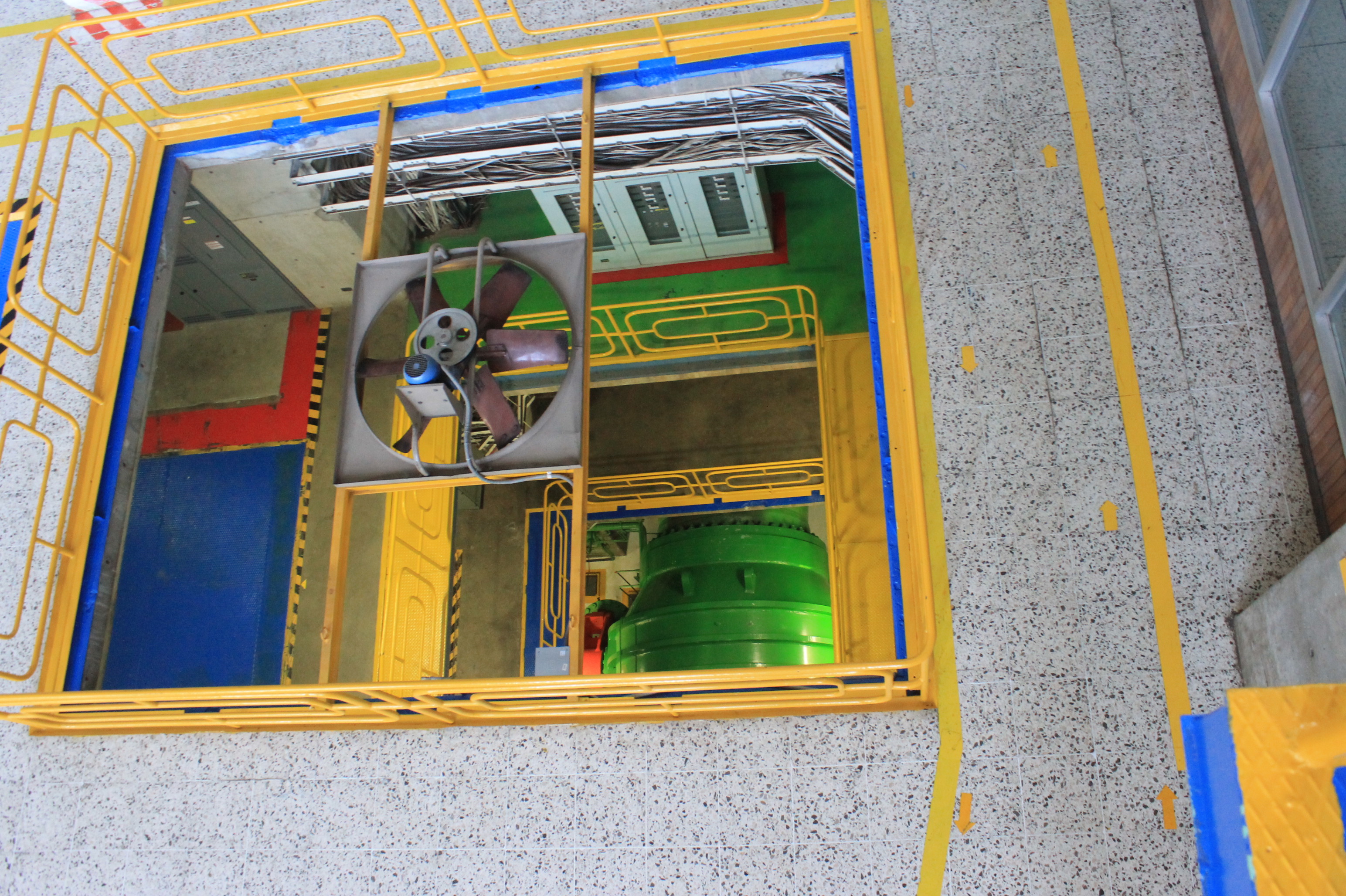
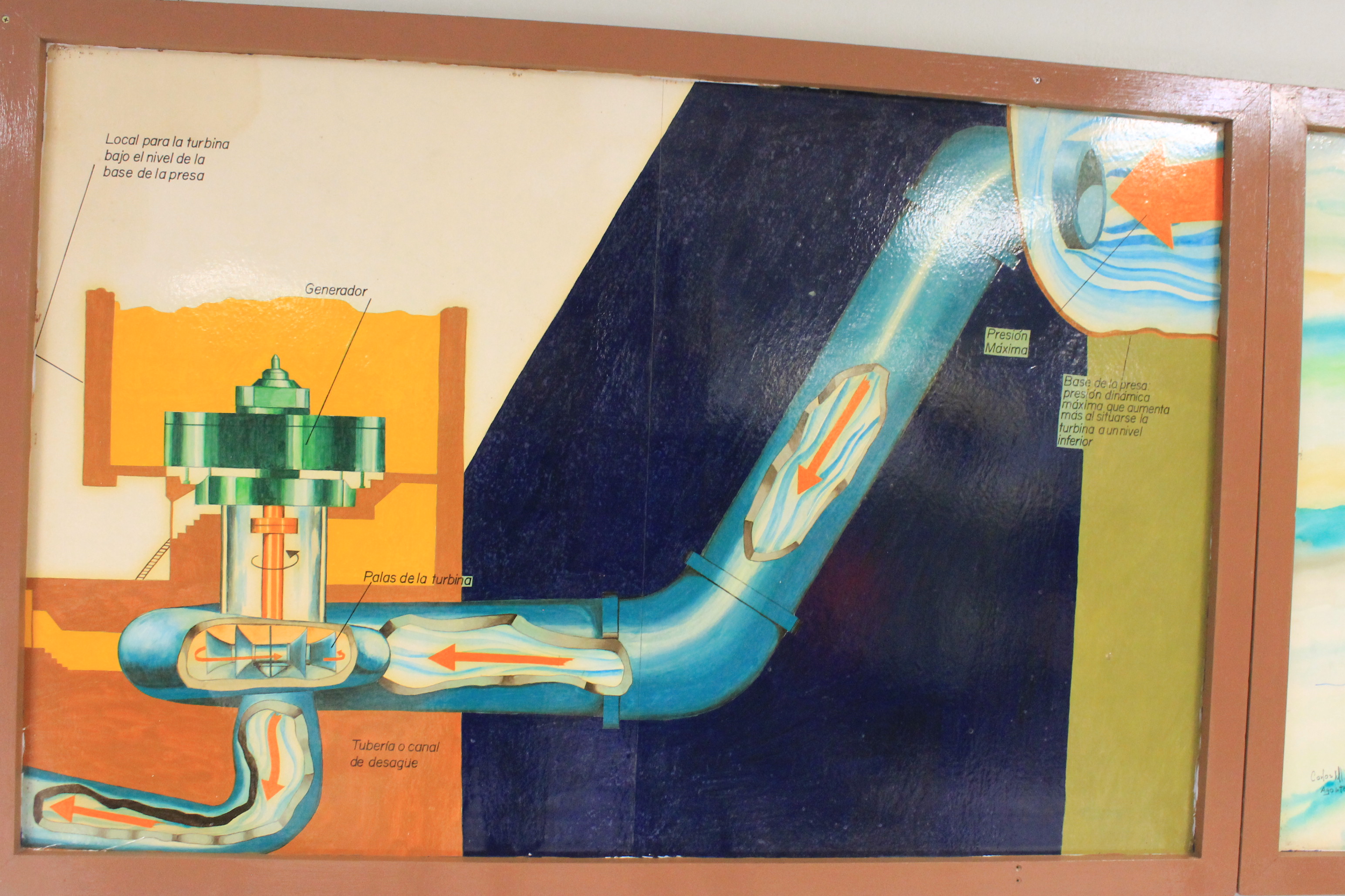


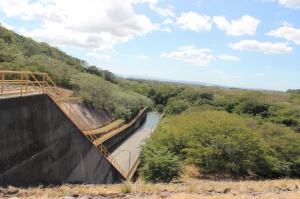
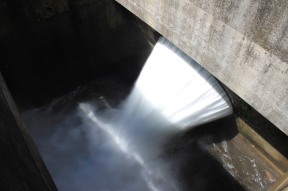
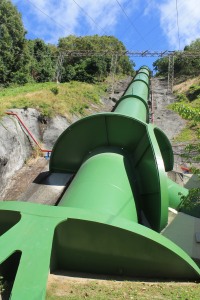
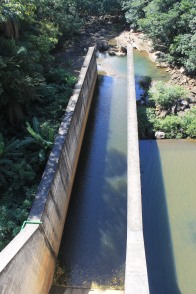
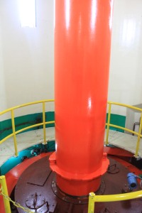
Figure 12. Hydroelectrical plants pictures. All photos taken by Maricruz Vargas.
Resources
- EPA-United States Environmental Protection Agency. http://water.epa.gov/type/watersheds/whatis.cf
- University of the Western Cape- Department of Biodiversity & Conservation Biology. http://www.bcb.uwc.ac.za/sci_ed/grade10/ecology/introduction.htm
- O´Keefe, T.; Elliot, S.; Naiman, R. Introduction to watershed ecology. University of Washington.
- Fernández,A. ; Aylward, B. Participación, pluralismo y policentrismo: el manejo de cuencas en Costa Rica. Depósito de documentos de la FAO http://www.fao.org/docrep/x3030s/x3030s0c.htm
- Rodríguez, E. Costa Rica en el siglo XX, tomo II. Editorial UNED p.p 130
- Rivera, N. La situación de manejo de cuencas en Costa Rica-Red Nacional de Cuencas. http://www.cne.go.cr/CEDO-CRID/CEDO-CRID%20v2.0/CEDO/pdf/spa/doc14470/doc14470.pdf
